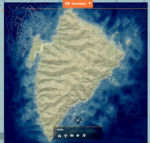
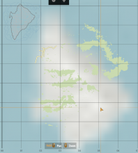
Upon creating a custom terrain, and using the export map data tool to create a topographical map, the map I am left with has forests, roads, buildings and other features placed correctly, but has the topography lines set in the top left corner of the map, and not overlaying on the map properly .
Description
Details
- Severity
- Minor
- Resolution
- Open
- Reproducibility
- Always
- Operating System
- Windows 10 x64
- Operating System Version
- Windows 11, Most recent.
- Category
- General
- Create new Terrain with heightmap and features
- Use Export Map Data tool to create a topographical map
- Use Map Entity to display map in game
- View map in game.
Map issue can be seen on Zer0Str0ngs Stratis port on workshop.
Event Timeline
Looks like you're using your own satmap texture, in theory it should work as well but there may be some issue related to it, could you try it with WB generated one?
Its also done in map export data, same as .topo file, but as a type select "rasterization" instead of Geometry2D
I've gone ahead and done that, it's honestly worse haha. I've attached two versions: the first is what it looks like with my own satmap texture, the second with the WB rasterization.
and here is what it looks like with the WB rasterization:
Not only is the rasterization flipped, but it's also extremely blurry, and the topography is still off.
sometimes the image is generated flipped, you can flip it manually before registering it to WB
is the blur present on generated source image as well or only ingame?
The image itself is generated flipped, so while yes, I can rotate it, doing so doesn't change much, since the image is still incredibly blurry.
The blur is only in game, the source image looks fine enough.
I've managed to fix the blur, but the contour lines are still broken. I'm really not sure what's causing it.
Out of curiosity, what was causing the blur?
The contour issue has been forwarded to responsible devs
I fixed the blur by opening the image in another program, rotating it, and then exporting and re-registering the file in the workbench.

